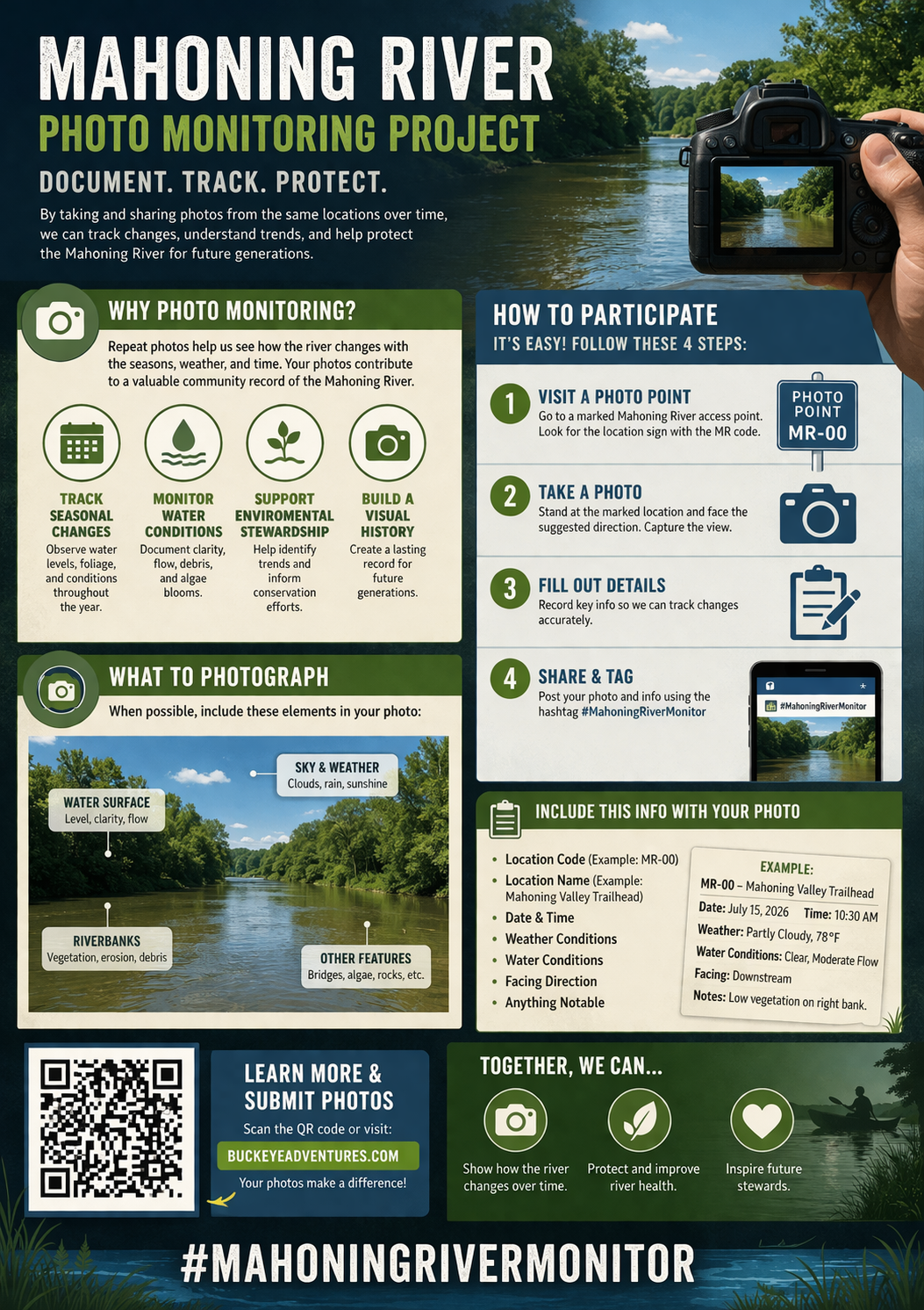

The Mahoning River Photo Monitoring System
Mahoning River Phenology
By
Buckeye Water to Trail Adventures LLC
© 2026 Buckeye Water to Trail Adventures LLC. All rights reserved.
What is Phenology?
Phenology is the study of seasonal changes in nature specifically when natural events happen and how they relate to weather and climate.
It focuses on things like:
🌿 When trees leaf out or change color
🌸 When flowers bloom
🐦 When birds migrate
🐸 When amphibians become active
🌊 Even changes in river conditions tied to seasons
👉 In simple terms:
Phenology = tracking nature’s calendar
Why Phenology Matters
Phenology helps us understand how ecosystems function and respond to change.
1. Climate Change Indicators
Shifts in timing (earlier blooms, later freezes) are early warning signs of climate change.
2. Ecosystem Health
If species fall out of sync (ex: flowers bloom before pollinators arrive), it can disrupt entire ecosystems.
3. River & Wildlife Patterns
For rivers like the Mahoning:
Fish spawning times
Algae growth
Water temperature changes
Flood cycles
All follow seasonal phenological patterns.
How to Take and Share a Mahoning River Photo Monitoring Photo
-
Help document the Mahoning River over time.
Visit a marked photo point, take a clear photo from the recommended location and direction, and upload it with the date, time, conditions, and location code. Share your post using #MahoningRiverMonitor and the correct #MM code so photos can be organized and compared over time.
Example Photo Details:
#MahoningRiverMonitor
#MM04
📍 Foster Metropark
📅 April 5, 2026
⏰ 3:15 PM
🌊 Moderate flow / slightly muddy
📸 Facing downstream
📝 Debris visible along river left after rain
-
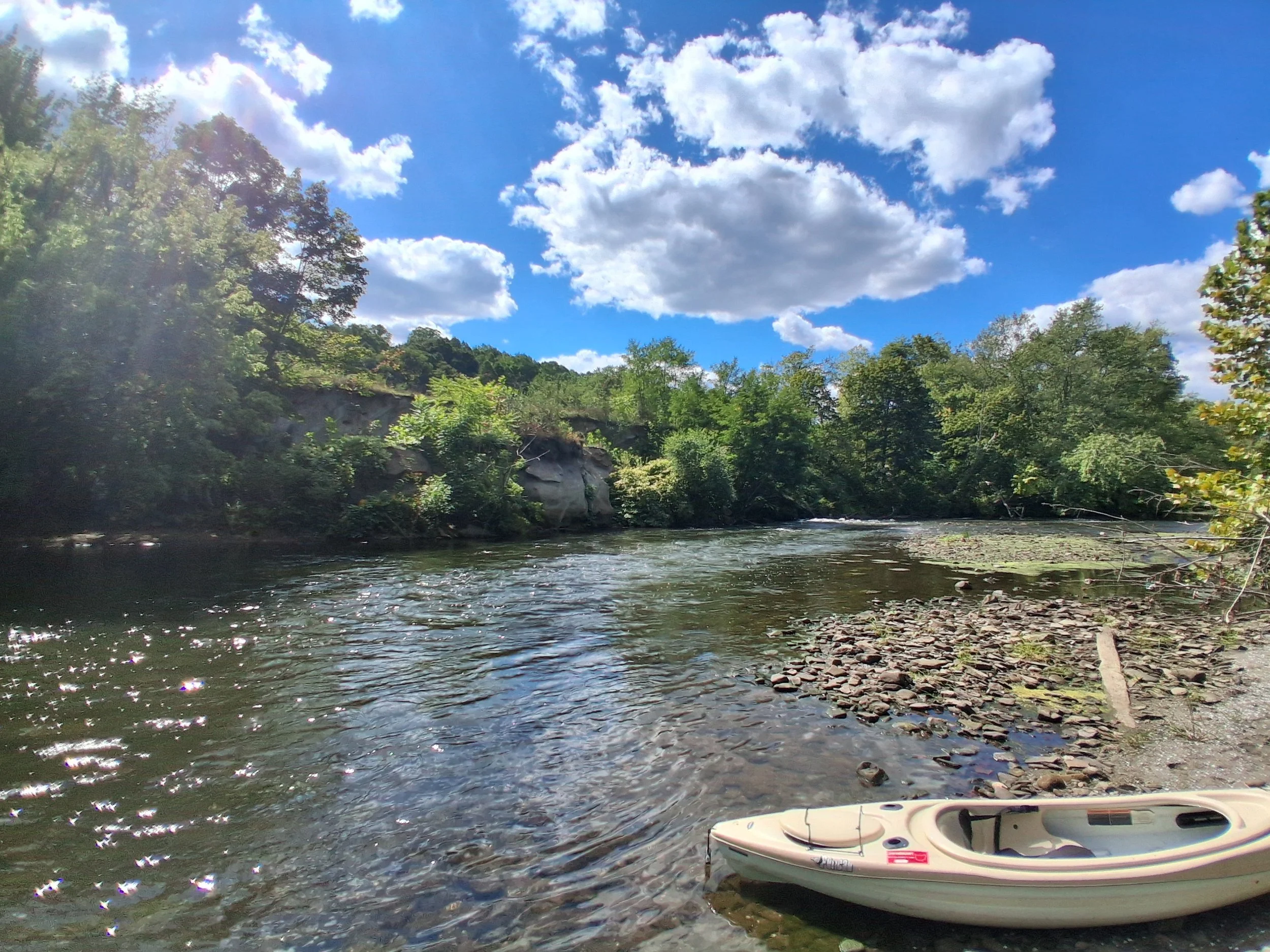
Visit one of the Mahoning River monitoring locations shown on the map.
Look for:
the MM location code
the access point name
the suggested photo area
Example: MM-04 | Foster Metropark
-
Go to the launch area, shoreline, or marked photo point.
Try to:
stand in the same general place each time
keep your view as consistent as possible
follow the suggested viewing direction
-
Before taking your photo, check the sign or instructions.
You may be asked to face:
downstream
upstream
toward a specific landmark or river feature
Consistency helps document how the river changes over time.
-
Use your phone or camera to take a clear photo.
Try to include:
river level
shoreline
trees and vegetation
weather or sky conditions
anything notable like debris, ice, algae, or cleanup progress
Tips:
hold your phone steady
take the photo in good light when possible
avoid zooming in too much
try to capture the same scene each visit
-
Before posting, note the following:
Location code
Location name
Date
Time
River conditions
Direction facing
Notes
Example:
Location: MM-04 | Foster Metropark
Date: April 5, 2026
Time: 3:15 PM
Conditions: Moderate flow, slightly muddy
Direction: Facing downstream
Notes: Debris along river left after recent rain
-
Upload your picture to the Google form linked below or email to mahoningrivermonitor@gmail.com.
https://forms.gle/YYE1kaBjczNGPb4q9
When posting:
attach your photo
copy and paste the template
fill in your details
include the correct hashtags
-
#MahoningRiverMonitor
#MM00
📍 Location:
📅 Date:
⏰ Time:
🌊 Conditions:
📸 Direction:
📝 Notes:
Delete:Change #MM00 to the correct location code.
See posted example or contact us for help!
-
Post your photo and check back another day, week, or season to take another one from the same spot.
Repeat photos help document:
seasonal change
water levels
vegetation growth
storm impacts
cleanup progress
overall river health
Changing of the Seasons!-
River Conditions
High water / fast current
Cold water temps
Increased debris (trees, runoff)
Nature Signals
Trees budding
First wildflowers
Amphibians active (frogs, salamanders)
Outfitter Notes:
⚠️ Advanced conditions
Great for education + observation, not beginners
-
River Conditions
Moderate flow
Clearing water
More stable levels
Nature Signals
Full leaf-out
Fish spawning
Birds nesting
Outfitter Notes:
✅ Ideal for classes + beginner trips
Peak time for your Intro to Kayaking
-
River Conditions
Lower water levels
Slower current
Warmer temps
Nature Signals
Dense vegetation
Algae growth possible
High wildlife activity
Outfitter Notes:
✅ Best for rentals + casual paddlers
⚠️ Watch for low water / obstacles
-
River Conditions
Moderate flow returns
Cooler water
Nature Signals
Leaf color change
Migration season
Reduced vegetation
Outfitter Notes:
🔥 Premium scenic trips
Best for guided experiences + photography
-
River Conditions
Cold, variable flow
Ice possible
Nature Signals
Dormant vegetation
Minimal wildlife
Outfitter Notes:
❌ Limited operations/ No on water trips available
Great for documentation + monitoring
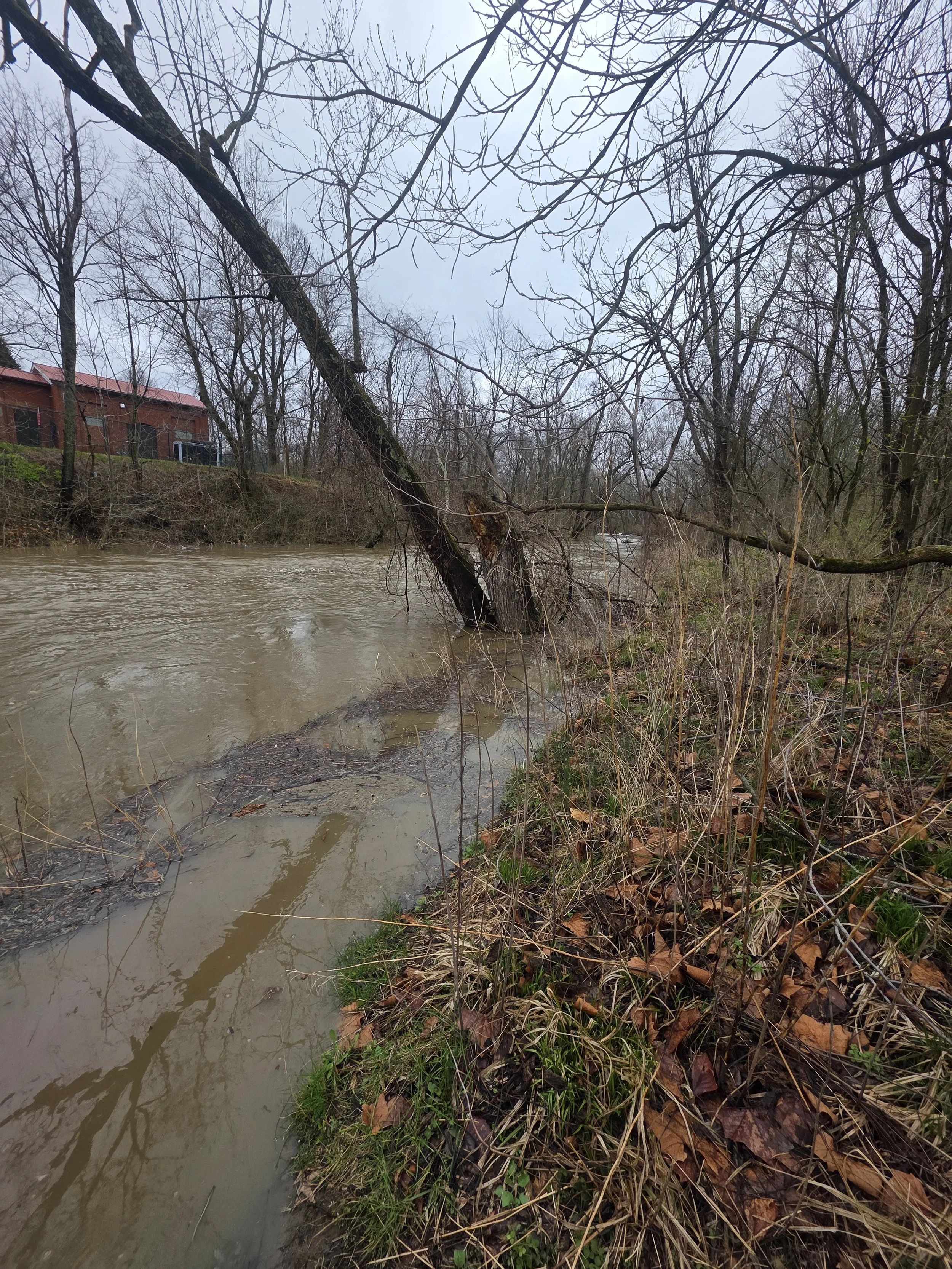
#MahoningRiverMonitor
#MM00
📍 Location: Mahoning Valley Trailhead
Alliance, OH
📅 Date: 4/2/2026
⏰ Time:5pm
🌊 Conditions: Heavy Rain/ Moderate flood stage
📸 Direction: Taken near gaskill bridge/ Downstream
📝 Notes: Normal water level approximately 2.5ft- River level today 8.9ft